Beginning with the American Civil War and moving forward to the present it is possible to find someone who announces that __________ war is “the most visual/photographed war” of all time. And for the most part they would be correct, at least for the time at which they were writing, as from the middle of the nineteenth century forward advanced visual and photographic technologies and the increasing mechanization of war kept pace with one another as two of the primary markers of modernity. The more important point, however, is that historically, advances in methods of visual surveillance and photographic technologies have frequently grown out of—or developed in intimate connection with—the modernization of the war machine itself.
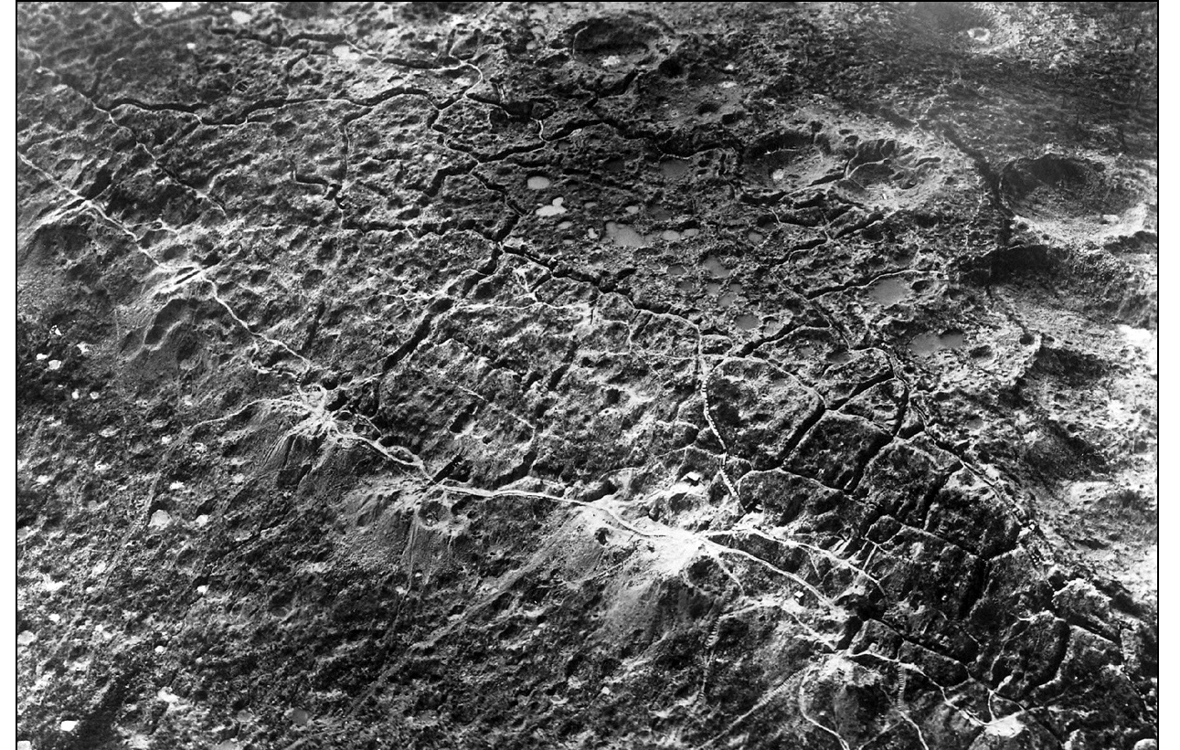
We have seen this relationship in contemporary times with spy satellites, various stealth and smart bomb technologies and, most recently, the use of drone warfare. But the point here is to recognize that the association between visual technologies and warfare is nothing new. The photograph above is a case in point. What you are looking at is an aerial photograph of the Hill of Combres, St. Mihiel Sector, in the North of France. The battles have ended by the time this photograph was taken, but what it shows is an aerial landscape of thousands of craters created by four years of artillery and mortar fire set against the criss-cross pattern of intersecting trenches in which hundreds of thousands from both sides in the “war to end all wars” died or were wounded.
Aerial photography was not invented during World War I, but it was developed and refined there as a way of enhancing map making and facilitating reconnaissance missions designed to record enemy movements and defense positions. Initially incorporated into its strategic and tactical planning by the French, by 1918 both the French and the Germans were taking photographs of the entire war front on a daily basis, producing nearly 500,000 aerial photographs by the war’s end, many of them employing advanced stereoscopic techniques that made it possible to measure the height of objects on the landscape. And in its own way, image making had become fully a part and parcel of the modern war machine.
There is no comfort in any of this, particularly as we recognize the fraught, parallel relationship between the development of visual technologies and advanced weapons systems that continues into present times. But then there is the photograph above which should stand as a reminder as to what such “advances” can produce. In its own way it is a memorial to the insanity of the “war to end all wars,” which converted habitable land into what has often been referred to as a desolate and “hellish moonscape.” The point, of course, is not that the past is a predictor of the future, but rather that the photograph itself is not simply an image of what once was, but can also serve as something of a prophecy as to how the seeds of a tragic future are already planted within the present if only we are careful enough to pay attention and to see it.
Credit: San Diego Air and Space Museum Archive
[…] via NO CAPTION NEEDEDSeeing War From Above » NO CAPTION NEEDED. […]